
The Bureau of Meteorology (BOM) has officially declared that El Niño is active, sparking immediate concerns for Australian farmers, water managers, and residents across the eastern states. This climate event, characterised by abnormally warm waters in the central tropical Pacific, is being tipped by advanced modelling to potentially become the strongest ever recorded in the modern era.
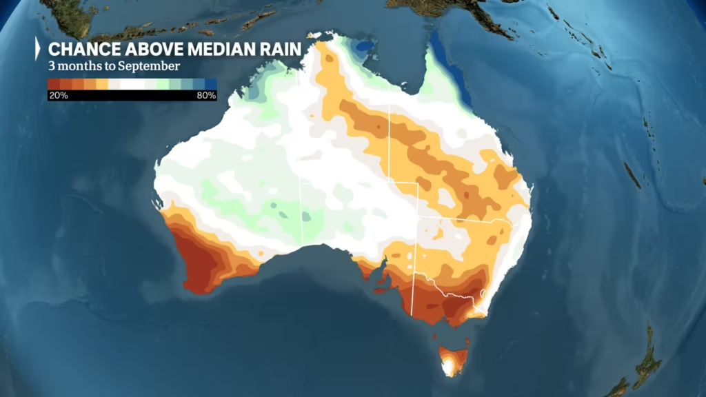
For Australians, the primary concern is a significant increase in the likelihood of below-median rainfall and higher-than-average temperatures, which could exacerbate drought conditions and elevate bushfire risks across the continent during the second half of 2026 and into 2027.
What Happened With El Niño 2026
In June 2026, the Bureau of Meteorology (BOM) confirmed the onset of an El Niño event after key ocean and atmospheric indicators crossed critical thresholds. The declaration follows a period of “neutral” Pacific conditions and the conclusion of a La Niña phase in early 2026.
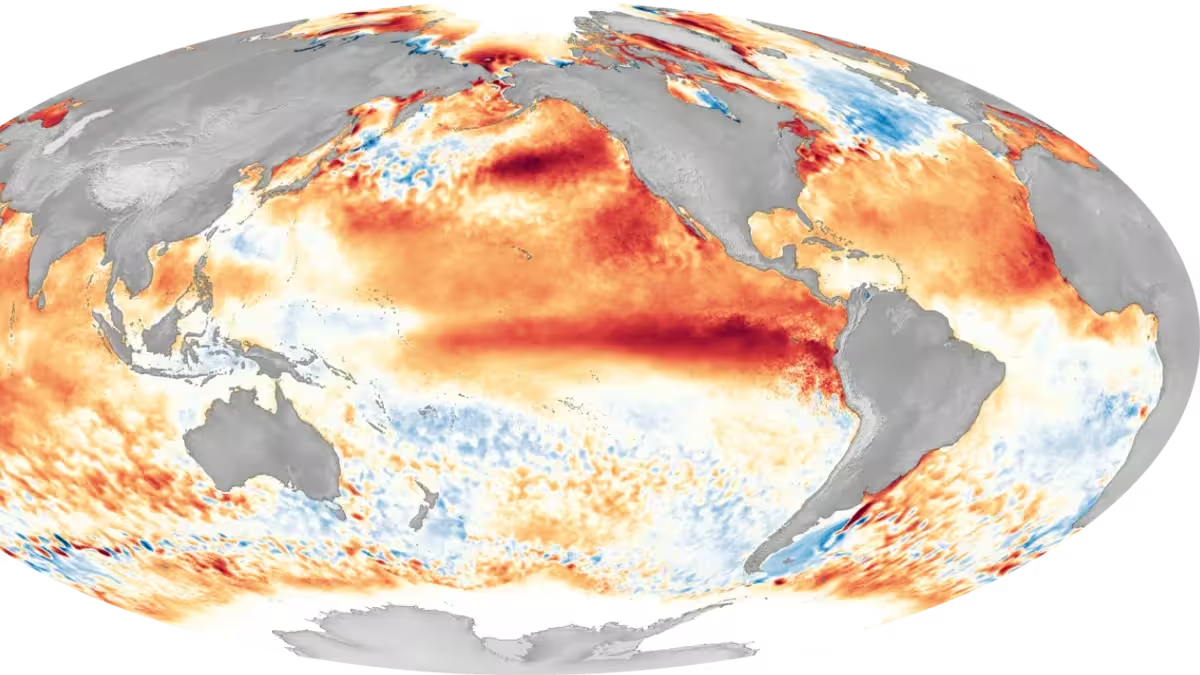
Meteorologists monitor the “Niño3.4 region”—a specific box of ocean along the equator—to gauge these shifts. Current readings show water temperatures exceeding the 0.8°C threshold required for a formal BOM declaration. Perhaps more alarming is the 30-day Southern Oscillation Index (SOI), which has plummeted to -23.3, far beyond the typical El Niño threshold of -7. This indicates a drastic shift in pressure patterns, where high pressure is now dominating Australian longitudes, effectively pushing rain-bearing systems away from the continent.
While many El Niño events do not peak until November or January, this particular cycle has emerged unusually early. The rate of warming in the Pacific is currently the fastest seen since 1943. Some models, including the ACCESS-S seasonal model, suggest peak warming could exceed 3°C above normal—surpassing the previous historical high of 2.65°C set in 1902.
Why El Niño Matters for Australia ?
For Australia, an El Niño declaration is rarely just a scientific observation; it is a signal for national preparation. Because the Australian climate is heavily influenced by the Pacific, El Niño typically correlates with drier-than-average conditions across the eastern and southern regions.
The timing of this event is critical. As the pattern intensifies through the spring and summer of 2026, it threatens to disrupt the agricultural cycle and strain urban water security. In a nation already grappling with the long-term effects of climate change, this natural cycle acts as a “force multiplier,” potentially pushing temperatures to unprecedented levels. This increases the volatility of the weather, making the transition from wet winters to scorching, dry summers more abrupt and severe.
El Niño 2026 – Key Details and Developments
There is a notable paradox currently playing out across the Australian landscape. Despite the official El Niño declaration, much of the country has experienced a wet start to June, with major north-west cloudbands dropping significant rain across the southern two-thirds of the nation.
Experts explain that this occurs because El Niño is an observation of Pacific conditions, not a guaranteed daily forecast. Australia’s weather is a complex interplay of multiple drivers. Currently, the Southern Ocean and the Indian Ocean are exerting a strong influence that favours rainfall, momentarily offsetting the drying effect of the Pacific. However, as the El Niño signal strengthens, these opposing forces are expected to shift.
Key statistical anomalies of the 2026 event include:
- Rapid Intensification: The speed of sea-surface temperature rises is unprecedented in recent decades.
- Consistency of Extremes: 2026 is on track to be the seventh consecutive year with either an El Niño or La Niña phase. Historically, about 50% of years are “neutral,” suggesting a disappearance of climate stability.
- Subsurface Heat: A massive reservoir of heat, some areas exceeding 6°C above average, is sitting below the ocean surface, providing the energy required to sustain and intensify the event through 2027.
Also Read – El Niño Australia 2026: Weather Forecast, Drought Risk and Bushfire Warnings
How El Niño will impact Australia
The consequences of a “strong” or “very strong” El Niño are felt most acutely across several key Australian sectors:
Agriculture and Farming
Primary producers in New South Wales, Queensland, and Victoria are the most vulnerable. El Niño typically reduces mid-to-late spring rainfall, which is critical for crop establishment. If the projected below-median rainfall manifests, the agricultural sector could see reduced yields in winter crops and a higher reliance on irrigation, putting further pressure on dwindling dam levels.
Water Security and Infrastructure
State governments in the Murray-Darling Basin will likely need to implement stricter water allocation plans. With the BOM tipping a drier second half of the year, the risk of water shortages for both livestock and urban consumption increases. City water authorities in Melbourne and Sydney may need to revisit water restriction triggers if the forecasted dryness persists into the summer.
Bushfire Risk and Public Safety
The combination of low humidity and above-average temperatures typically associated with El Niño creates a “tinderbox” effect. Rural Fire Services (RFS) and Country Fire Services (CFS) across Australia are expected to prepare for a high-risk fire season. The potential for “extreme” or “catastrophic” fire days increases as the atmospheric pressure patterns push moist air away from the coast and inland.
Economic Implications
Drier conditions often lead to higher food prices for Australian consumers as crop failures drive up the cost of domestic produce. Furthermore, the energy sector may face increased demand for cooling as heatwaves become more frequent and intense, potentially straining the electrical grid in peak summer months.
Expert Analysis and Outlook
Climatologists emphasize that while the strength of the Pacific warming is record-breaking, there is a weak direct relationship between the temperature of the Pacific and the exact amount of rainfall lost in Australia. A “super El Niño” does not automatically guarantee a record-breaking drought, as local atmospheric conditions and other ocean drivers (like the Indian Ocean Dipole) can mitigate the effects.
However, there is a consensus that this event is “riding on top” of global warming. Professor Adam Scaife and other climate experts warn that because the baseline global temperature has risen, the actual heat felt on the ground in Australian cities like Perth, Brisbane, and Adelaide could be unprecedented. The heat is not just coming from the El Niño cycle, but from the broader trend of human-caused climate change.
The World Meteorological Organization (WMO) and NOAA both highlight that while the event may peak between November 2026 and February 2027, the atmospheric disruptions will likely persist well into 2027, potentially making it one of the hottest years on record globally.
What Happens Next?
Over the next six months, the Bureau of Meteorology will continue to monitor the Niño3.4 region and the SOI to track the intensification of the event. Australians should expect the following progression:
- Winter/Early Spring: Continued volatility where local ocean drivers may still provide occasional rain, but the overall trend begins to dry.
- Late Spring (October-November): A likely decline in rainfall across eastern Australia as the El Niño signal becomes the dominant driver.
- Summer Peak (December-February): The highest risk for extreme heatwaves and severe fire weather, coinciding with the peak of the Pacific warming.
- 2027 Transition: A potential “hangover” effect where the atmosphere remains warm, leading to a hot start to the following year.
Conclusion
The official declaration of El Niño 2026 serves as a critical early warning for the Australian community. While current rains offer a temporary reprieve, the underlying climate data points toward a challenging period of dryness and extreme heat. By understanding that this event is potentially one of the strongest on record, Australian businesses, governments, and individuals can take proactive steps to manage water, protect crops, and prepare for an intensified bushfire season. Staying informed via the Bureau of Meteorology will be essential as this Pacific warming event evolves throughout the remainder of the year.
Frequently Asked Questions
What is El Niño and how does it affect Australia?
El Niño is a climate pattern where surface waters in the central and eastern tropical Pacific Ocean become warmer than average. For Australia, this typically shifts rainfall patterns, leading to drier-than-normal conditions and higher temperatures, particularly in the eastern and northern regions.
Does an El Niño declaration mean a drought is guaranteed?
No. While El Niño increases the probability of drought and below-median rainfall, it is not a guarantee. Other factors, such as the Indian Ocean Dipole and Southern Ocean temperatures, can influence local weather and may bring rain even during an El Niño year.
How strong is the 2026 El Niño event?
The Bureau of Meteorology and international agencies like NOAA suggest this could be one of the strongest events in modern history. Some models predict sea-surface temperature anomalies exceeding 3°C, which would break the previous record set in 1902.
When will the impacts of El Niño 2026 be most felt in Australia?
While the event is active now, the most significant impacts on rainfall and temperature typically occur during the peak of the cycle, which is forecast for November 2026 through February 2027.
Why is it raining in some parts of Australia if El Niño has started?
El Niño is a large-scale ocean-atmosphere pattern, but local weather is driven by many factors. Currently, north-west cloudbands and influences from the Indian and Southern Oceans are bringing rain to parts of Australia, which can temporarily mask the drying effect of El Niño.
How does climate change interact with El Niño?
Climate change increases the baseline temperature of the planet. When a natural warming event like El Niño occurs, it adds extra heat on top of an already warmer world, making heatwaves more intense and droughts potentially more severe.