
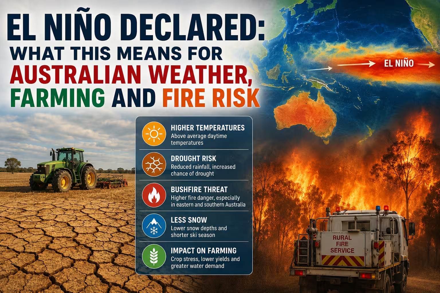
Australia is bracing for a significant shift in climate patterns after the US National Oceanic and Atmospheric Administration (NOAA) officially confirmed that an El Niño is now underway in the Pacific Ocean. For Australians, the arrival of this climate driver typically signals an increased risk of severe drought, intensifying heatwaves, and a heightened threat of bushfires across the east coast and southern regions.
While some parts of the country are currently experiencing an unseasonably warm and wet start to winter, experts warn that these conditions may be short-lived as the El Niño pattern begins to dominate the domestic weather profile from July onwards.
What Happened?
The National Oceanic and Atmospheric Administration (NOAA) has formally declared the onset of an El Niño event. This natural climate phenomenon occurs when sea surface temperatures in the central and eastern tropical Pacific Ocean become substantially warmer than average, causing a reversal or weakening of the equatorial trade winds.
Meteorologists are particularly concerned about the potential scale of this event. According to NOAA, there is a 63 per cent probability that this year’s El Niño could rank among the largest on record since data collection began in 1950. Some analysts suggest it could rival or even exceed the catastrophic 1997-98 event, which resulted in billions of dollars in global damages due to extreme weather whiplash.
Why El Niño 2026 matters for Australia
The El Niño-Southern Oscillation (ENSO) is one of the most influential drivers of Australia’s year-to-year climate variability. When an El Niño is present, the heavy rainfall that typically settles north of Australia shifts east toward the central Pacific. This redistribution of moisture often leaves the Australian continent—particularly the east and north—significantly drier than usual during the winter and spring months.
The timing is critical. While Australia is currently in the midst of a record-breaking warm start to winter, the long-term modelling suggests a transition toward drier conditions. For the Australian economy, which relies heavily on agricultural output and stable water resources, a strong El Niño can translate into reduced crop yields, increased water restrictions, and escalating costs for disaster management.
El Niño 2026 – Impact on Australians
The consequences of an El Niño event are felt across multiple sectors of Australian society, from the rural heartlands to the urban centres of Sydney, Melbourne, and Brisbane.
Agricultural and Rural Sector
Farmers are already on high alert. Historically, El Niño events are closely linked to severe droughts in the Murray-Darling Basin. In fact, nine of the ten driest winter-spring periods on record for eastern Australia occurred during El Niño years. While grain producers in the Western Australian Wheatbelt and parts of Queensland may currently be benefitting from unexpected June rains, the long-term outlook is concerning.
Agricultural experts warn that increased evaporative demand caused by higher temperatures will exacerbate the lack of rainfall, potentially threatening livestock and crop viability across the southern states.
Bushfire and Heatwave Risk
The combination of reduced rainfall and increased maximum temperatures significantly elevates the fire danger rating in southeast Australia. Historically, severe seasons—such as the Ash Wednesday fires—have been associated with these conditions. When El Niño coincides with a positive Indian Ocean Dipole (IOD), the risk of a catastrophic fire season increases exponentially.
Alpine Regions and Tourism
For the ski industry in New South Wales and Victoria, the outlook is bleak. El Niño typically results in lower snow depths and shorter seasons. The current “warm start” to winter has already melted significant portions of early June snow, exposing bare grass at many resorts. With nights remaining above freezing, artificial snowmaking has been severely limited, threatening the viability of the July school holiday peak.
Urban Centers and Public Health
Major cities are already seeing the anomalies. Sydney is on track for its warmest start to winter since records began in 1859, with maximums consistently above 20°C. While mild weather is welcomed by some, it indicates a disruption in normal seasonal cooling. The subsequent heatwaves associated with El Niño can lead to increased energy demand for cooling and heightened health risks for vulnerable populations in cities like Perth, Adelaide, and Canberra.
Expert Analysis and Outlook
There is a slight divergence in expert opinion regarding the “severity” of this event. While the NOAA warns of a record-breaking event, some experts argue that a “Super El Niño” (where temperatures are 2 to 2.5°C above average) is unlikely. This is partly because the current event follows a rare “triple La Niña” (2020-2022), and historically, such sequences do not typically culminate in a super event.
However, the consensus remains that this will be a strong event. Climate scientists, including those from Clark University, suggest that a warming globe acts as fuel for these natural cycles. The “background warming” trend means that every subsequent El Niño has a higher baseline temperature, making the resulting heatwaves and droughts more intense than those experienced in the mid-20th century.
What Happens Next?
In the immediate term, Australians can expect the current “Tasman High” pressure system to shift by late June, potentially allowing some colder Southern Ocean air to move in. However, the overarching El Niño influence is expected to solidify from July onwards.
Government agencies and the Bureau of Meteorology will continue to monitor the Southern Oscillation Index (SOI) and NINO3.4 sea surface temperatures. State governments in New South Wales, Victoria, and Queensland are likely to ramp up bushfire preparedness and water management strategies in anticipation of a drier spring and summer.
Conclusion
The declaration of an El Niño serves as a critical warning for Australia to prepare for volatile weather. While the current unseasonable warmth and sporadic rainfall in the south have provided a temporary reprieve for some farmers, the long-term trajectory points toward increased dryness and heat. By understanding the mechanisms of the El Niño-Southern Oscillation and preparing for the likely reduction in rainfall and increased fire risk, Australian businesses and communities can better mitigate the economic and environmental impacts of this powerful climate driver.
Frequently Asked Questions
What is an El Niño and how does it affect Australia?
El Niño is a climate pattern involving the warming of the central and eastern tropical Pacific Ocean. In Australia, it typically leads to reduced rainfall (especially in the north and east), higher daytime temperatures, and an increased risk of drought and bushfires.
Is this a “Super El Niño”?
While the US NOAA indicates a 63% chance of this being one of the strongest events since 1950, some experts believe a full “Super El Niño” is unlikely due to the preceding triple La Niña event. However, it is still expected to be a strong event with significant impacts.
Why is it so warm in Sydney and Melbourne right now if it’s winter?
The current warmth is primarily due to high-pressure systems in the Tasman Sea directing northerly winds over the east coast and blocking cold fronts from the south. This is an atmospheric setup that is currently masking the broader El Niño influence.
How does El Niño impact the Australian ski season?
El Niño generally leads to lower peak snow depths and a shorter overall season in the Australian Alps. This year, unseasonably high temperatures have already melted early snow, which may negatively impact the July ski holiday period.
Will El Niño cause a drought in Australia in 2026?
While not every El Niño causes a widespread drought, the probability is significantly higher. Historically, many of Australia’s worst droughts have coincided with El Niño years, particularly in the Murray-Darling Basin.
Does El Niño increase the risk of cyclones in Australia?
Actually, El Niño typically results in fewer tropical cyclones in the Australian region, particularly around Queensland, as the rainfall and storm activity shift eastward across the Pacific.